Understand groundwater and eflows
Showing all 9 results
-
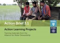
Action Brief 3.1: Action Learning Projects (2018)
The projects aim to assess the current water use trends, identify and map out the key stakeholders, shared water-related risks, challenges and opportunity at the site and catchment level, and develop a water stewardship plan following the framework of AWS Standard.
-
Automated Geospatial Watershed Assessment Tool (2018)
This tool is a GIS-based hydrologic modeling tool designed for both novice and expert GIS users.
-
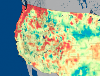
Global Groundwater Maps and U.S. Drought Forecasts (2020)
NASA researchers have developed new satellite-based, weekly global maps of soil moisture and groundwater wetness conditions and one to three-month U.S. forecasts of each product.
-
Groundwater Exchange (2018)
The Groundwater Exchange is an online resource center connecting water managers, water users, and community members with tools and resources to support the design and implementation of effective Groundwater Sustainability Plans under California’s Sustainable Groundwater Management Act.
-

Indicators of Hydrologic Alteration (IHA) (2018)
Indicators of Hydrologic Alteration (IHA) is a software program that allows water resource managers, hydrologists, ecologists, researchers and policy makers to assess how rivers, lakes and groundwater basins have been affected by human activities over time – or to evaluate future water management scenarios.
-

Itza Popo – Replenishing Groundwater through Reforestation in Mexico (2017)
Volkswagen partnered with Comisión Nacional de Áreas Naturales Protegidas and local stakeholders to restore the functionality of the ecosystems on the volcanic slopes of Popocatépetl and Iztaccíhuatl in order to replenish groundwater in the Puebla Tlaxcala valley.
-
Managed Aquifer Recharge Portal (2018)
Managed aquifer recharge (MAR) represents a viable method for sustainable water management. This viewer provides a global overview of MAR suitability maps and MAR case studies and their relevant parameters.
